|
Lexical NOAA/HRPT and FY-1D/CHRPT and MTSAT Solutions for BMG Jakarta, Indonesia. |

|
Lexical Technology Pte Ltd |
|
Your Partner In Remote Sensing Solutions. |


|
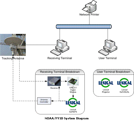
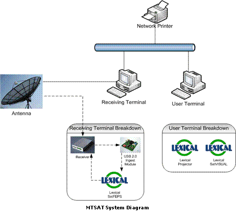
Lexical successfully installed and commissioned three Ground Station Reception Systems: NOAA/FY-1D and MTSAT for BMG Jakarta. Each System has been customized to the specific needs of BMG. The following diagrams illustrates the above-mentioned installations. |
|
NOAA/FY-1D System BMG requires satellite data from the polar-orbiting satellites passing over it. The consequence of having such a large array of polar-orbiting satellites passing over BMG (which averages to about 1 pass per hour) is that BMG has to have a scalable and robust system that can handle such high volumes of data. |
|
14 Sep 2006 |


|
MTSAT System Lexicalís MTSAT system can receive hourly full disk image or half hourly half disk image from the Japanese geostationary satellite. It is a cost effective and powerful tool to monitor the cloud weather system over large areas and particularly useful in detecting and monitoring tropical typhoon. After the installation, the MTSAT systemís ability is demonstrated with the detection of a tropical typhoon hitting Taiwan. The hourly images received from MTSAT help forecaster to track and predict the path of the typhoon. For this system, the geostationary version of SatFEPS is used to ingest and preprocess the raw data. Similar to Lexicalís NOAA/FY-1Dís system architecture, the preprocessed data is projected and displayed by SatVISUAL. Similar to the NOAA/FY-1D system, level 2 products from MTSAT are also generated using SatVISUAL. |

|
Lexicalís NOAA/FY-1D system can receive data from NOAA 12, 15, 16, 17, 18 and Chinese FY-1D polar orbiting satellites. A single Lexical NOAA/FY-1D system is capable of receiving data from multiple satellites, doing away with the need to install multiple systems. Total cost for BMG is minimized because only a single system is required to receive data from these polar orbiting satellite. This is much accredited to Lexical SatFEPS. SatFEPS can detect schedule conflicts between satellites and make automatic decisions to receive data from only one of the satellite passing over. Pre-processing of ingested data is also taken care by Lexical SatFEPS. The pre-processed raw data are then projected and viewed by Lexical SatVISUAL installed on Usersí Terminals. Using SatVISUAL, level 2 products can be produced in a timely and efficient manner. With Lexicalís NOAA/FY-1D system in place, BMG can now make use of high resolution data from NOAA and FY-1D satellites to monitor the regionís climate comfortably. |